|
| Fact Sheet Title Fact Sheet |
| |
| Tusk - Mid-Atlantic Ridge |
 | Tusk on Mid-Atlantic Ridge (Areas Xb, XIIc, Va, XIIa and XIVb) |
| | Data Ownership | | This document provided, maintained and owned by International Council for the Exploration of the Sea (ICES) , is part of ICES Advice data collection. |
|
| ident Block | ident Block | | | | Species List: | | Species Ref: en - Tusk(=Cusk), fr - Brosme, es - Brosmio, ar - بروسمة, zh - 单鳍鳕, ru - Менек (=морской налим) |
|
|
| ident Block Tusk - Mid-Atlantic Ridge Map tips - Click on
 to turn layers on and off to turn layers on and off - Double-click to zoom in
- Drag to pan
- Hold down the shift key and drag to zoom to a particular region
| fao Div |
|---|
| 27.14.b | Southeast Greenland (Division 27.14.b) |
|---|
| 27.12.c | Central Northeast Atlantic - South (Division 27.12.c) |
|---|
| 27.5.a | Iceland Grounds (Division 27.5.a) |
|---|
| 27.10.b | Northeast Atlantic South (Division 27.10.b) |
|---|
| 27.12.a | Southern mid-Atlantic Ridge (Division 27.12.a) |
|---|
|
|
|
|
|
| Aq Res | Biological Stock: Yes Value: Sub-Regional
Reference year: 2008 |
| Considered a management unit: An aquatic resource or fishery is declared as [Fishery] Management Unit if it is effectively the focus for the application of selected management methods and measures, within the broader framework of a management system. According to the FAO Glossary for Responsible Fishing, "a Fishery Management Unit (FMU) is a fishery or a portion of a fishery identified in a Fishery Management Plan (FMP) relevant to the FMP's management objectives." FMU's may be organised around fisheries biological, geographic, economic, technical, social or ecological dimensions , and the makeup and attribute of a fishery management unit depends mainly on the FMP's management objectives. |
| Jurisdictional distribution: Jurisdictional qualifier (e.g. "shared", "shared - highly migratory") of the aquatic resource related with its spatial distribution. |
| Environmental group: Classification of the aquatic resource according to the environmental group (e.g. pelagic invertebrate, or demersal fish) to which the species belong. |
| Reference Year: The Reference Year is the last year considered in the stock assessment and/or fishery status. |
| | | | | | Aq Res State Trend Fisheries in this area take very small catches of tusk. There is no information on the state of the stock. Habitat Bio Depth Zone: Slope (200 m - 1000 m). Vertical Dist: Demersal/Benthic. Water Area Overview Spatial Scale: Sub-Regional Water Area Overview  | | Water Area Overview Tusk - Mid-Atlantic Ridge
| fao Div | 27.14.b: Southeast Greenland (Division 27.14.b) | | 27.12.c: Central Northeast Atlantic - South (Division 27.12.c) | | 27.5.a: Iceland Grounds (Division 27.5.a) | | 27.10.b: Northeast Atlantic South (Division 27.10.b) | | 27.12.a: Southern mid-Atlantic Ridge (Division 27.12.a) |
| | | | | | Water Area Overview |
Water Area OverviewTusk - Mid-Atlantic Ridge | fao Major | 27: Atlantic, Northeast | | Large Marine Ecosystem Areas (LME) | 19: East Greenland Shelf | | 21: Norwegian Shelf | | 59: East Greenland Shelf/Sea | | 60: Faroe Plateau |
Aq Res Struct Biological Stock: Yes Bio Assess Assess Models Methodology Scientific basis Catches from this area have been small and no scientific analyses have been carried out. Comparison with previous assessment and advice This is the first time advice has been given for this area. Previous advice was given for all areas combined. Results Table 9.4.12.3.1. Tusk XII. WG estimate of landings. Note: catches in XIIb (Hatton Bank) may be included in these data. | TUSK XII | | | | | | | | | Year | Faroes | France | Iceland | Norway | Scotland | Russia | Total | | 1988 | | 1 | | | | | 1 | | 1989 | | 1 | | | | | 1 | | 1990 | | 0 | | | | | 0 | | 1991 | | 1 | | | | | 1 | | 1992 | | 1 | | | | | 1 | | 1993 | | 12 | + | | | | 12 | | 1994 | | 1 | + | | | | 1 | | 1995 | 8 | - | 10 | | | | 18 | | 1996 | 7 | - | 9 | 142 | | | 158 | | 1997 | 11 | - | + | 19 | | | 30 | | 1998 | | 1 | | - | | | 1 | | 1999 | | 1 | | + | 1 | | 1 | | 2000 | | | | 5 | + | | 5 | | 2001 | | 1 | | 51 | + | | 52 | | 2002 | | | | 27 | | | 27 | | 2003 | | | | 83 | | | 83 | | 2004 | 2 | 2 | | 7 | | 5 | 16 | | 2005 | 2 | 1 | | | | | 3 | | 2006 | | 0 | | | | 64 | 64 | | 2007* | | 0 | | | | 19 | 19 | | *Preliminary. | 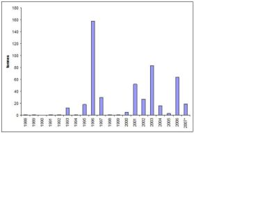 | Figure 9.4.12.3.1. Tusk XII. WG estimate of landings (tonnes). Note: catches in XIIb (Hatton Bank) may be included in these data.  |
Ref Point Reference points for this stock have not been calculated. Reference points that were previously suggested for tusk would be based on unexploited abundance; however, the data to calculate this point do not exist. Sci Advice Single-stock exploitation boundaries Fisheries on tusk should be accompanied by programmes to collect data on both target and bycatch fish. Fisheries should not be allowed to expand unless there is information that can be used to evaluate a long-term sustainable level of exploitation. Management Advice Management considerations Catches of tusk are reported for Area XII and may include catches in Area XIIb (Hatton Bank). Tusk is a bycatch species in the gillnet and longline fisheries in Subarea/Division XII. In the last two years only Russia has reported catches of tusk. During the period 1996 to 2004 Norway also had a fishery in this area. Sources ICES.2009.Report of the ICES Advisory Committee, 2009. ICES Advice, 2009. |
|
| |
|