|
| Fact Sheet Title Fact Sheet |
| |
| Norway lobster - West European Basin (Ireland SW and SE coast) |
 | Nephrops off the southeastern and southwestern coasts of Ireland (FU19) |
| | Data Ownership | | This document provided, maintained and owned by International Council for the Exploration of the Sea (ICES) , is part of ICES Advice data collection. |
|
| ident Block | ident Block | | | | Species List: | | Species Ref: en - Norway lobster, fr - Langoustine, es - Cigala |
|
|
| ident Block Norway lobster - West European Basin (Ireland SW and SE coast)
Map tips
- Click on
 to turn layers on and off to turn layers on and off
- Double-click to zoom in
- Drag to pan
- Hold down the shift key and drag to zoom to a particular region
| fao Div |
|---|
| 27.7.a | Irish Sea (Division 27.7.a) |
|---|
| 27.7.g | Celtic Sea North (Division 27.7.g) |
|---|
| 27.7.j | Southwest of Ireland - East (Division 27.7.j) |
|---|
| ices Fu Nep |
|---|
| 19 | |
|---|
|
|
|
|
|
| Aq Res | Biological Stock: Yes
Value: Sub-Regional
Management unit: No
Reference year: 2012
|
| Considered a management unit: An aquatic resource or fishery is
declared as [Fishery] Management Unit if it is
effectively the focus for the application of selected
management methods and measures, within the broader
framework of a management system. According to the FAO
Glossary for Responsible Fishing, "a Fishery Management
Unit (FMU) is a fishery or a portion of a fishery
identified in a Fishery Management Plan (FMP) relevant
to the FMP's management objectives." FMU's may be
organised around fisheries biological, geographic,
economic, technical, social or ecological dimensions ,
and the makeup and attribute of a fishery management
unit depends mainly on the FMP's management
objectives. |
| Jurisdictional distribution: Jurisdictional qualifier (e.g.
"shared", "shared - highly migratory") of the aquatic
resource related with its spatial distribution. |
| Environmental group: Classification of the aquatic
resource according to the environmental group (e.g.
pelagic invertebrate, or demersal fish) to which the
species belong. |
| Reference Year: The Reference Year is the last year considered in the stock assessment and/or fishery status. |
| | | | | | Aq Res State Trend 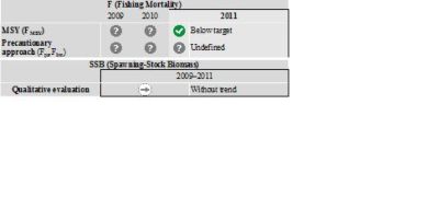 | Figure 5.4.34.5.1  |
The current harvest rates are below the MSY reference points. Biomass in relation to MSY B trigger cannot be evaluated. Lpue has fluctuated without trend since 1995. Habitat Bio Depth Zone: Shelf (50 m - 200 m). Vertical Dist: Demersal/Benthic. This area has numerous small and spatially distinct mud patches. Survey information indicates consistent differences in mean length and size in catches between mud patches, suggesting variable population densities and growth; however, the overall trend has remained stable over time. Sampling of commercial landings shows large variations in size because of this. Geo Dist Geo Dist: Shared between nations Water Area Overview Spatial Scale: Sub-Regional
Ecoregion: Celtic Sea.
Water Area Overview  | | Water Area Overview Norway lobster - West European Basin (Ireland SW and SE coast)
| fao Div | 27.7.a: Irish Sea (Division 27.7.a) | | 27.7.g: Celtic Sea North (Division 27.7.g) | | 27.7.j: Southwest of Ireland - East (Division 27.7.j) | | ices Fu Nep | 19: |
| | | | | | Water Area Overview |
Water Area OverviewNorway lobster - West European Basin (Ireland SW and SE coast) Aq Res Struct Biological Stock: Yes Exploit The fisheriesThis is mainly an otter trawl fishery using single- and twin-rigs and a codend mesh size of 80–99 mm.
| Catch distribution |
Total catch (2011) = 745 t, where 82% were landings (100% otter trawl) and 18% discards. |
Effects of the fisheries on the ecosystemNephrops fisheries in this area have bycatches of megrim, hake, and monkfish. Bio Assess Sci Advice ICES advises on the basis of the MSY approach that landings in 2013 should be no more than 820 t. To protect the stock in this functional unit, management should be implemented at the functional unit level. Results 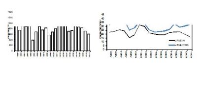 | | Figure 5.4.34.5.1 Nephrops off the southeastern and southwestern coasts of Ireland (FU 19). Left: Long-term trends in landings (tonnes). Right: Landings per unit effort (lpue, kg hr−1) for all vessels targeting Nephrops (black line) and for vessels >18 m total length (blue line). |
Assess Models Quality considerationA relatively extensive UWTV survey was conducted for the first time in 2011. This gave estimates of burrow densities for several of the main patches of Nephrops habitat in FU 19. However, one of the main patches was not surveyed. The survey abundance could be used to provide management advice for the first time. Mean size in the landings has been quite variable over the time-series, partially reflecting the difference in mean sizes of patches with different underlying densities. Adequate catch sampling remains difficult for such a heterogeneous area. Scientific basis
| Assessment type |
UWTV survey and trends in size structure of catches. |
| Input data |
One survey index (UWTV-FU 19), size structure of catches. |
| Discards and bycatch |
Discards are included in the assessment. |
| Indicators |
Mean size in landings. Historical survey indicators (IRGFS-WIBTS-Q4) commenced in 2003. |
| Other information |
This stock is scheduled to be benchmarked in 2013. |
| Working group report |
WGCSE |
Management Management unit: No Management plansNo specific management objectives are known to ICES. Sources The above excerpts are from the first two pages of the ICES advice, the supporting information to this advice can be read in full at the following reference: ICES. Nephrops off the southeastern and southwestern coasts of Ireland (FU19). Report of the ICES Advisory Committee, 2012. ICES Advice, June 2012.  http://www.ices.dk/committe/acom/comwork/report/2012/2012/Nep-VII.pdf http://www.ices.dk/committe/acom/comwork/report/2012/2012/Nep-VII.pdf |
|
| |
|