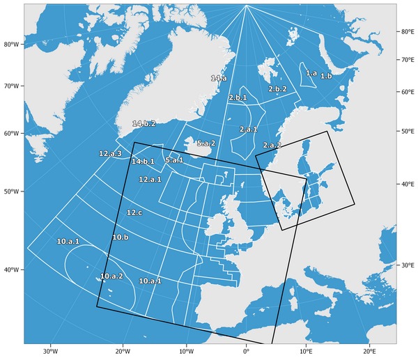
 Fig. 1 shows the boundaries of the Atlantic, Northeast (Major Fishing Area 27) corresponding to the ICES fishing areas for statistical purposes. |
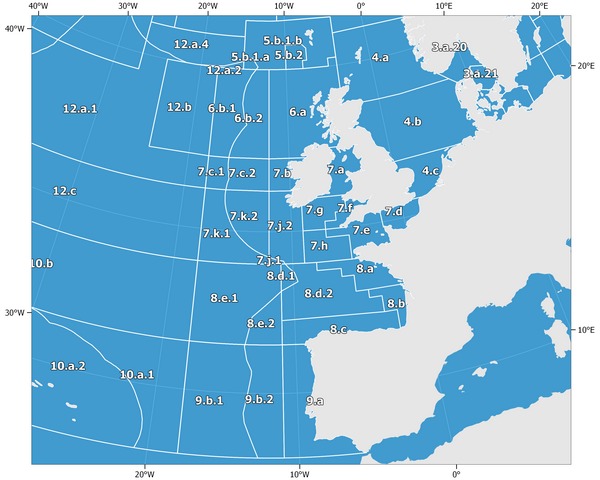 Fig. 2 shows the detailed boundaries of the ICES subareas 27.4, 27.5, 27.6, 27.7, 27.8, 27.9. |
| - Barents Sea (Subarea 27.1)
{1, 1.a, 1.b}
- Norwegian Sea, Spitzbergen, and Bear Island (Subarea 27.2)
{2, 2.a, 2.a.1, 2.a.2, 2.b, 2.b.1, 2.b.2}
- Skagerrak, Kattegat, Sound, Belt Sea, and Baltic Sea (Subarea 27.3)
{3, 3.a, 3.a.20, 3.a.21, 3.b,c, 3.c.22, 3.b.23, 3.d, 3.d.24, 3.d.25, 3.d.26, 3.d.27, 3.d.28, 3.d.28.1, 3.d.28.2, 3.d.29, 3.d.30, 3.d.31, 3.d.32}
- North Sea (Subarea 27.4)
{4, 4.a, 4.b, 4.c}
- Iceland and Faroes Grounds (Subarea 27.5)
{5, 5.a, 5.a.1, 5.a.2, 5.b, 5.b.1, 5.b.1.a, 5.b.1.b, 5.b.2}
- Rockall, Northwest Coast of Scotland and North Ireland (Subarea 27.6)
{6, 6.a, 6.b, 6.b.1, 6.b.2}
- Irish Sea, West of Ireland, Porcupine Bank, Eastern and Western English Channel, etc (Subarea 27.7)
{7, 7.a, 7.b, 7.c, 7.c.1, 7.c.2, 7.d, 7.e, 7.f, 7.g, 7.h, 7.j, 7.j.1, 7.j.2, 7.k, 7.k.1, 7.k.2}
- Bay of Biscay (Subarea 27.8)
{8, 8.a, 8.b, 8.c, 8.d, 8.d.1, 8.d.2, 8.e, 8.e.1, 8.e.2}
- Portuguese Waters (Subarea 27.9)
{9, 9.a, 9.b, 9.b.1, 9.b.2}
- Azores Grounds and Northeast Atlantic South (Subarea 27.10)
{10, 10.a, 10.a.1, 10.a.2, 10.b}
- Subarea XI
{11}
- North of Azores (Subarea 27.12)
{12, 12.a, 12.a.1, 12.a.2, 12.a.3, 12.a.4, 12.b, 12.c}
- Subarea XIII
{13}
- East Greenland (Subarea 27.14)
{14, 14.a, 14.b, 14.b.1, 14.b.2}
|
|
A description of the area and its subareas, divisions and subdivisions follows:
All waters of the Atlantic and Arctic Oceans and their dependent seas bounded by a line from the geographic North Pole along the meridian of 40°00' west longitude to the north coast of Greenland; thence in an easterly and southerly direction along the coast of Greenland to a point at 44°00' west longitude; thence due south to 59°00' north latitude; thence due east to 42°00' west longitude; thence due south to 36°00' north latitude; thence due east to a point on the coast of Spain (Punta Marroqui isthmus) at 5°36' west longitude; thence in a northwesterly and northerly direction along the southwest coast of Spain, the coast of Portugal, the north-west and north coasts of Spain, and the coasts of France, Belgium, the Netherlands, and Germany to the western terminus of its boundary with Denmark; thence along the west coast of Jutland to Thyborøn; thence in a southerly and easterly direction along the south coast of the Limfjord to Egensekloster Point; thence in a southerly direction along the east coast of Jutland to the eastern terminus of the boundary of Denmark with Germany; thence along the coasts of Germany, Poland, Russian Federation, Lithuania, Latvia, Estonia, Russian Federation, Finland, Sweden, and Norway, and the north coast of the Russian Federation to Khaborova; thence across the western entry of the Strait of Yugorskiy Shar; thence in a westerly and northerly direction along the coast of Vaigach Island; thence, across the western entry of the Strait of the Karskiye Vorota; thence west and north along the coast of the south island of Novaya Zemlya; thence across the western entry of the Strait of Matochkin Shar; thence along the west coast of the north island of Novaya Zemlya to a point at 68°30' east longitude; thence due north to the geographic North Pole.
|
| Barents Sea (Subarea 27.1) | | |
The waters bounded by a line from the geographic North Pole along the meridian of 30°00' east longitude to 72°00' north latitude; thence due west to 26°00' east longitude; thence due south to the coast of Norway; thence in an easterly direction along the coasts of Norway and the Russian Federation to Khaborova; thence across the western entry of the Strait of Yugorskiy Shar; thence in a westerly and northerly direction along the coast of Vaigach Island; thence across the western entry of the Strait of the Karskiye Vorota; thence west and north along the coast of the south island of Novaya Zemlya; thence across the western entry of the Strait of Matochkin Shar; thence along the west coast of the north island of Novaya Zemlya to a point at 68°30' east longitude; thence due north to the geographic North Pole.
|
| Barents Sea - NEAFC Regulatory Area (Division 27.1.a) | | | An area inside Subarea 27.1 identical to NEAFC Area III and defined as the area confined by the following coordinates:
 Coordinates of Division 27.1.a Coordinates of Division 27.1.aCoordinates of Division 27.1.a| Latitude (N) | Longitude ('+'=E, '-'=W) | | 73.98 | 33.70 | | 74.18 | 34.55 | | 74.36 | 35.28 | | 74.71 | 36.38 | | 75.14 | 37.57 | | 75.45 | 38.31 | | 75.84 | 39.05 | | 76.26 | 39.61 | | 76.61 | 41.24 | | 76.90 | 42.81 | | 76.90 | 43.06 | | 76.75 | 44.68 | | 75.99 | 43.51 | | 75.39 | 43.18 | | 74.82 | 41.73 | | 73.98 | 41.56 | | 73.17 | 40.66 | | 72.20 | 40.51 | | 72.26 | 39.76 | | 72.62 | 38.96 | | 73.04 | 37.74 | | 73.37 | 36.61 | | 73.56 | 35.70 |
|
|
| Barents Sea Non-NEAFC Regulatory Area (Division 27.1.b) | | | The parts of ICES Subarea 27.1 outside NEAFC III (=Division 1a).
|
| Norwegian Sea, Spitzbergen, and Bear Island (Subarea 27.2) | | |
The waters bounded by a line from the geographic North Pole along the meridian of 30°00' east longitude to 72°00' north latitude; thence due west to 26°00' east longitude; thence due south to the coast of Norway; thence in a westerly and southwesterly direction along the coast of Norway to 62°00' north latitude; thence due west to 4°00' west longitude; thence due north to 63°00' north latitude; thence due west to 11°00' west longitude; thence due north to 63°00' north latitude; thence due west to 11°00' west longitude; thence due north to the geographic North Pole.
|
| Norwegian Sea (Division 27.2.a) | | |
The waters bounded by a line beginning at a point on the coast of Norway at 62°00' north latitude; thence due west to 4°00' west longitude; thence due north to 63°00' north latitude; thence due west to 11°00' west longitude; thence due north to 73°30' north latitude; thence due east to 30°00' east longitude; thence due south to 72°00' north latitude; thence due west to 26°00' east longitude; thence due south to the coast of Norway; thence in a westerly and southwesterly direction along the coast of Norway to the point of beginning.
|
| Norwegian Sea - NEAFC Regulatory Area (Division 27.2.a.1) | | |
Southern Part of the NEAFC area II (south of 73²30' N) defined by the following coordinates:
Coordinates of Division 27.2.a.1Coordinates of Division 27.2.a.1| Latitude (N) | Longitude ('+'=E, '-'=W) | | 73.50 | -0.20 | | 73.50 | 7.21 | | 73.45 | 7.28 | | 73.14 | 7.83 | | 72.76 | 8.65 | | 72.49 | 9.33 | | 72.31 | 9.83 | | 72.18 | 10.29 | | 71.98 | 9.94 | | 71.91 | 9.70 | | 71.64 | 8.75 | | 71.36 | 7.93 | | 71.13 | 7.42 | | 70.79 | 6.73 | | 70.17 | 5.64 | | 69.79 | 5.01 | | 69.56 | 4.74 | | 69.32 | 4.32 | | 69.10 | 4 | | 68.86 | 3.73 | | 68.69 | 3.57 | | 68.46 | 3.40 | | 68.23 | 3.27 | | 67.98 | 3.19 | | 67.77 | 3.16 | | 67.57 | 3.15 | | 67.37 | 3.18 | | 67.18 | 3.24 | | 67.01 | 3.31 | | 66.84 | 3.42 | | 66.43 | 3.27 | | 66.39 | 3.18 | | 66.23 | 2.79 | | 65.95 | 2.24 | | 65.64 | 1.79 | | 65.38 | 1.44 | | 65.32 | 1.26 | | 65.08 | 0.72 | | 64.72 | 0.04 | | 64.43 | -0.49 | | 64.84 | -1.31 | | 64.92 | -1.56 | | 65.13 | -2.17 | | 65.22 | -2.54 | | 65.39 | -3.19 | | 65.47 | -3.73 | | 65.55 | -4.19 | | 65.59 | -4.56 | | 65.69 | -5.58 | | 65.96 | -5.60 | | 66.22 | -5.67 | | 66.47 | -5.78 | | 67.09 | -6.25 | | 67.61 | -6.62 | | 67.77 | -5.33 | | 67.96 | -4.19 | | 68.10 | -3.42 | | 68.33 | -2.39 | | 68.55 | -1.56 | | 68.86 | -0.61 | | 69.14 | 0.08 | | 69.44 | 0.68 | | 69.76 | 1.18 | | 69.97 | 1.46 | | 70.21 | 1.72 | | 70.43 | 1.94 | | 70.63 | 2.09 | | 70.89 | 2.25 | | 71.14 | 2.35 | | 71.35 | 2.39 | | 71.61 | 2.38 | | 71.83 | 2.31 | | 72.01 | 2.22 | | 72.24 | 2.06 | | 72.43 | 1.89 | | 72.60 | 1.68 | | 72.75 | 1.48 | | 72.99 | 1.08 | | 73.31 | 0.34 | | 73.50 | -0.20 |
|
|
| Norwegian Sea Non-NEAFC Regulatory Area (Division 27.2.a.2) | | | The remaining part of ICES Division 27.2.a.
|
| Spitzbergen and Bear Island (Division 27.2.b) | | |
The waters bounded by a line from the geographic North Pole along the meridian of 30°00' east longitude to 73°30' north latitude; thence due west to 11°00' west longitude; thence due north to the geographic North Pole.
|
| Spitzbergen and Bear Island - NEAFC Regulatory Area (Division 27.2.b.1) | | |
The NEAFC area II north of 73° 30' N as defined by the following coordinates:
Coordinates of Division 27.2.b.1Coordinates of Division 27.2.b.1| Latitude (N) | Longitude ('+'=E, '-'=W) | | 73.50 | 7.21 | | 73.50 | -0.20 | | 73.60 | -0.48 | | 73.94 | -1.88 | | 74.09 | -2.70 | | 74.21 | -5.00 | | 74.50 | -4.38 | | 75.00 | -4.29 | | 75.30 | -4.19 | | 76.05 | -4.30 | | 76.18 | -4.09 | | 76.57 | -2.52 | | 76.67 | -2.10 | | 76.56 | -1.60 | | 76.00 | 0.80 | | 75.87 | 1.12 | | 75.64 | 1.71 | | 75.21 | 3.06 | | 74.96 | 4.07 | | 74.86 | 4.55 | | 74.69 | 5.19 | | 74.34 | 6.39 | | 74.13 | 6.51 | | 73.89 | 6.74 | | 73.60 | 7.06 | | 73.50 | 7.21 |
|
|
| Spitzbergen and Bear Island Non-NEAFC Regulatory Area (Division 27.2.b.2) | | | The remaining parts of ICES Division 27.2.b not in the NEAFC Area II.
|
| Skagerrak, Kattegat, Sound, Belt Sea, and Baltic Sea (Subarea 27.3) | 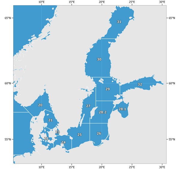 Fig. 3, map of the Baltic Sea showing the subdivisions of the Belt, the Sound, and the Baltic for the reporting of catch statistics. |
| |
The waters bounded by a line beginning at a point on the coast of Norway at 7°00' east longitude; thence due south to 57°30' north latitude; thence due east to 8°00' east longitude; thence due south to 57°00' north latitude; thence due east to the coast of Denmark; thence along the northwest and east coasts of Jutland to Hals; thence across the eastern entrance of the Limfjord to Egensekloster Point; thence in a southerly direction along the coast of Jutland to the eastern terminus of the boundary of Denmark and Germany; thence along the coasts of Germany, Poland, Russian Federation, Lithuania, Latvia, Estonia, Russian Federation, Finland, Sweden, and Norway to the point of beginning.
|
| Skagerrak and Kattegat (Division 27.3.a) | | | The waters bounded by a line beginning at a point on the coast of Norway at 7°00' east longitude; thence due south to 57°30' north latitude; thence due east to 8°00' east longitude; thence due south to 57°00' north latitude; thence due east to the coast of Denmark; thence along the northwest and east coasts of Jutland to Hals; thence across the eastern entrance of the Limfjord to Egensekloster Point; thence in a southerly direction along the coast of Jutland to Hasenøre Head; thence across the Great Belt to Gniben Point; thence along the north coast of Zealand to Gilbjerg Head; thence across the northern approaches of the Øresund to the Kullen on the coast of Sweden; thence in an easterly and northerly direction along the west coast of Sweden and the south coast of Norway to the point of beginning.
|
| Skagerrak (Subdivision 27.3.a.20) | | |
The geographical area bounded on the west by a line drawn from the Hanstholm lighthouse to the Lindesnes lighthouse and on the south by a line drawn from the Skagen lighthouse to the Tilstlarna lighthouse and from this point to the nearest point on the Swedish coast.
|
| Kattegat (Subdivision 27.3.a.21) | | |
The geographical area bounded on the north by a line drawn from the Skagen lighthouse to the Tilstlarna lighthouse and from this point to the nearest point on the Swedish coast and on the south by a line drawn from Hasenøre Head on the east coast of Jutland thence across the Great Belt to Gniben Point on the west coast of Zealand, thence along the north coast of Zealand to Gilbjerg Head; thence across the northern approaches of the Øresund to the Kullen on the coast of Sweden.
|
| Sound and Belt Sea or the Transition Area (Divisions 27.3.b,c) | | | The waters bounded by a line from Hasenøre Head on the east coast of Jutland to Gniben Point on the west coast of Zealand to Gilbjerg Head; thence across the northern approaches of the Øresund to the Kullen on the coast of Sweden; thence in a southerly direction along the coast of Sweden to Falsterbo Light; thence across the southern entrance of the Øresund to Stevns Light; thence along the southeast coast of Zealand; thence across the eastern entrance of the Storstrøm Sound; thence along the east coast of the island of Falster to Gedser Odde (54°34' north latitude, 11°58' east longitude); thence due east to 12°00' east longitude; thence due south to the coast of Germany; thence along the coast of Germany and the east coast of Jutland to the point of beginning.
|
| Belt Sea (Subdivision 27.3.c.22) | | |
The waters bounded by a line from Hasenøre Head (56°09' north latitude, 10°44' east longitude) on the east coast of Jutland to Gniben Point (56°01' north latitude, 11°18' east longitude) on the west coast of Zealand; thence along the west and south coasts of Zealand to a point at 12°00' east longitude; thence due south to the island of Falster; thence along the east coast of the island of Falster to Gedser Odde (54°34' north latitude, 11°58' east longitude); thence due east to 12°00' east longitude; thence due south to the coast of Germany; thence along the coast of Germany and the east coast of Jutland to the point of beginning.
|
| Sound (Subdivision 27.3.b.23) | | |
The waters bounded by a line from Gilbjerg Head (56°08' north latitude, 12°18' east longitude) on the north coast of Zealand to Kullen (56°18' north latitude, 12°28' east longitude) on the coast of Sweden; thence in a southerly direction along the coast of Sweden to the Falsterbo Light (55°23' north latitude, 12°50' east longitude); thence through the southern entrance to the Sound to the Stevns Light (55°18' north latitude, 12°27' east longitude) on the coast of Zealand; thence in a northerly direction along the east coast of Zealand to the point of beginning.
|
| Baltic Sea (Division 27.3.d) | | |
The waters of the Baltic Sea and its dependent gulfs, bights, and firths bounded to the west by a line from Falsterbo Light on the southwest coast of Sweden across the southern entrance of the Øresund to Stevns Light; thence along the southeast coast of Zealand; thence across the eastern entrance of the Storstrøm Sound; thence along the east coast of the island of Falster to Gedser Odde (54°34' north latitude, 11°58' east longitude); thence due east to 12°00' east longitude; thence due south to the coast of Germany.
|
| Baltic West of Bornholm (Subdivision 27.3.d.24) | | |
The waters bounded by a line from the Stevns Light (55°18' north latitude, 12°27' east longitude) on the east coast of Zealand through the southern entrance to the Sound to the Falsterbo Light (55°23' north latitude, 12°50' east longitude) on the coast of Sweden; thence along the south coast of Sweden to the Sandhammaren Light (55°24' north latitude, 14°12' east longitude); thence to the Hammerodde Light (55°18' north latitude, 14°47' east longitude) on the north coast of Bornholm; thence along the west and south coasts of Bornholm to a point at 15°00' east longitude; thence due south to the coast of Poland; thence in a westerly direction along the coasts of Poland and Germany to a point at 12°00' east longitude; thence due north to a point at 54°34' north latitude, 12°00' east longitude; thence due west to Gedser Odde (54°34' north latitude, 11°58' east longitude); thence along the east and north coasts of the island of Falster to a point at 12°00 east longitude; thence due north to the south coast of Zealand; thence in a westerly and northerly direction along the west coast of Zealand to the point of beginning.
|
| Southern Central Baltic - West (Subdivision 27.3.d.25) | | |
The waters bounded by a line beginning at a point on the east coast of Sweden at 56°30' north latitude; thence due east to the west coast of the island of Öland; then, after passing south of the island of Öland to a point on the east coast at 56°30' north latitude, due east to 18°00' east longitude; thence due south to the coast of Poland; thence in a westerly direction along the coast of Poland to a point at 15°00' east longitude; thence due north to the island of Bornholm; thence along the south and west coasts of Bornholm to the Hammerodde Light (55°18' north latitude, 14°47' east longitude); thence to the Sandhammaren Light (55°24' north latitude, 14°12' east longitude) on the south coast of Sweden; thence in a northerly direction along the east coast of Sweden to the point of beginning.
|
| Southern Central Baltic - East (Subdivision 27.3.d.26) | | |
The waters bounded by a line beginning at a point at 56°30' north latitude, 18°00' east longitude; thence due east to the west coast of Latvia; thence in a southerly direction along the coasts of Latvia, Lithuania, Russian Federation and Poland to a point on the Polish coast at 18°00' east longitude; thence due north to the point of beginning.
|
| West of Gotland (Subdivision 27.3.d.27) | | |
The waters bounded by a line beginning at a point on the east mainland coast of Sweden at 59°41' north latitude, 19°00' east longitude; thence due south to the north coast of the island of Gotland; thence in a southerly direction along the west coast of Gotland to a point at 57°00' north latitude; thence due west to 18°00' east longitude; thence due south to 56°30' north latitude; thence due west to the east coast of the island of Öland; thence, after passing south of the island of Öland, to a point on its west coast at 56°30' north latitude; thence due west to the coast of Sweden; thence in a northerly direction along the east coast of Sweden to the point of beginning.
|
| East of Gotland or Gulf of Riga (Subdivision 27.3.d.28) | | |
The waters bounded by a line beginning at a point at 58°30' north latitude, 19°00' east longitude; thence due east to the west coast of the island of Saaremaa; thence, after passing north of the island of Saaremaa, to a point on its east coast at 58°30' north latitude; thence due east to the coast of the Estonia; thence in a southerly direction along the west coast of Estonia and Latvia to a point at 56°30' north latitude; thence due west to 18°00' east longitude; thence due north to 57°00' north latitude; thence due east to the west coast of the island of Gotland; thence in a northerly direction to a point on the north coast of Gotland at 19°00' east longitude; thence due north to the point of beginning.
|
| Gulf of Riga (Unit 27.3.d.28.1) | | | "Gulf of Riga" means the area bounded on the west by a line drawn from Ovisi lighthouse (57° 34.1234' N, 21° 42.9574' E) on the west coast of Latvia to the Southern Rock of Cape Loode (57° 57.4760' N, 21° 58.2789' E) on the island of Saaremaa, then southwards to the southernmost point of the peninsula of Sõrve and then in a north-eastern direction along the east coast of the island of Saaremaa, and in the north by a line drawn from 58°30.0' N 23°13.2'E to 58°30.0'N 23°41'1E.
|
| East of Gotland (Open Sea) (Unit 27.3.d.28.2) | | | Those parts of Subdivision 28 outside the Gulf of Riga.
|
| Archipelago Sea (Subdivision 27.3.d.29) | | |
The waters bounded by a line beginning at a point on the east mainland coast of Sweden at 60°30' north latitude; thence due east to the mainland coast of Finland; thence in a southerly direction along the west and south coasts of Finland to a point on the south mainland coast at 23°00' east longitude; thence due south to 59°00' north latitude; thence due east to the mainland coast of Estonia; thence in a southerly direction along the west coast of Estonia to a point at 58°30' north latitude; thence due west to the east coast of the island of Saaremaa; thence, after passing north of the island of Saaremaa, to a point on its west coast at 58°30' north latitude; thence due west to 19°00' east longitude; thence due north to a point on the east mainland coast of Sweden at 59°41' north latitude; thence in a northerly direction along the east coast of Sweden to the point of beginning.
|
| Bothnian Sea (Subdivision 27.3.d.30) | | |
The waters bounded by a line beginning from a point on the east coast of Sweden at 63°30' north latitude, thence due east to the mainland coast of Finland; thence in a southerly direction along the coast of Finland to a point at 60°30' north latitude; thence due west to the mainland coast of Sweden; thence in a northerly direction along the east coast of Sweden to the point of beginning.
|
| Bothnian Bay (Subdivision 27.3.d.31) | | |
The waters bounded by a line beginning at a point on the east coast of Sweden at 63°30' north latitude; thence, after passing north of the Gulf of Bothnia, to a point on the west mainland coast of Finland at 63°30' north latitude; thence due west to the point of beginning.
|
| Gulf of Finland (Subdivision 27.3.d.32) | | | The waters bounded by a line beginning at a point on the south coast of Finland at 23°00′ east; then, after passing east of the Gulf of Finland, to a point on the west coast of Estonia at 59°00′ north; then due west to 23°00′ east; then due north to the point of beginning.
|
| North Sea (Subarea 27.4) | | |
The waters bounded by a line beginning at a point on the coast of Norway at 62°00' north latitude; thence due west to 4°00' west longitude; thence due south to the coast of Scotland; thence in an easterly and southerly direction along the coasts of Scotland and England to a point at 51°00' north latitude; thence due east to the coast of France; thence in a northeasterly direction along the coasts of France, Belgium, the Netherlands, and Germany to the western terminus of its boundary with Denmark; thence along the west coast of Jutland to Thyborøn; thence in a southerly and easterly direction along the south coast of the Limfjord to Egensekloster Point; thence across the eastern entrance of the Limfjord to Hals; thence in a westerly direction along the north coast of the Limfjord to the southernmost point of Agger Tange; thence in a northerly direction along the west coast of Jutland to Hanstholm lighthouse; thence in a northwesterly direction to the Lindesnes lighthouse; thence due north to the coast of Norway; thence in a northwesterly direction along the coast of Norway to the point of beginning.
|
| Northern North Sea (Division 27.4.a) | | |
The waters bounded by a line beginning at a point on the coast of Norway at 62°00' north latitude; thence due west to 4°00' west longitude; thence due south to the coast of Scotland; thence in an easterly and southerly direction along the coast of Scotland to a point at 57°30' north latitude; thence due east to the line between the Lindesnes lighthouse and the Hanstholm lighthouse; thence due northwest alongside this line; thence in a northwesterly direction along the coast of Norway to the point of beginning.
|
| Central North Sea (Division 27.4.b) | | |
The waters bounded by a line beginning at the Hanstholm lighthouse; thence northwest alongside the line towards the Lindesnes lighthouse up until the 57.5 degrees north latitude; thence due west to the coast of Scotland; thence in a southerly direction along the coasts of Scotland and England to a point at 53°30' north latitude; thence due east to the coast of Germany; thence in a northeasterly direction along the coast of Jutland to Thyborøn; thence in a southerly and easterly direction along the south coast of the Limfjord to Egensekloster Point; thence across the eastern entrance of the Limfjord to Hals; thence in a westerly direction along the north coast of the Limfjord to the southernmost point of Agger Tange; thence in a northerly direction along the west coast of Jutland to the point of beginning.
|
| Southern North Sea (Division 27.4.c) | | |
The waters bounded by a line beginning at a point on the west coast of Germany at 53°30' north latitude; thence due west to the coast of England; thence in a southerly direction to a point at 51°00' north latitude; thence due east to the coast of France; thence in a northeasterly direction along the coasts of France, Belgium, the Netherlands, and Germany to the point of beginning.
|
| Iceland and Faroes Grounds (Subarea 27.5) | | |
The waters bounded by a line beginning at a point at 68°00' north latitude, 11°00' west longitude; thence due west to 27°00' west longitude; thence due south to 62°00' north latitude; thence due east to 15°00' west longitude; thence due south to 60°00' north latitude; thence due east to 5°00 west longitude; thence due north to 60°30' north latitude; thence due east to 4°00' west longitude; thence due north to 63°00' north latitude; thence due west to 11°00' west longitude; thence due north to the point of beginning.
|
| Iceland Grounds (Division 27.5.a) | | |
The waters bounded by a line beginning at a point at 68°00' north latitude, 11°00' west longitude; thence due west to 27°00' west longitude; thence due south to 62°00' north latitude; thence due east to 15°00' west longitude; thence due north to 63°00' north latitude; thence due east to 11°00' west longitude; thence due north to the point of beginning.
|
| Northern Reykjanes Ridge (Subdivision 27.5.a.1) | | |
The area inside the rectangle defined by the following coordinates:
|
| Icelandic Shelf (Subdivision 27.5.a.2) | | |
The remaining parts of the Division 27.5.a not in Subdivision 27.5.a.1.
|
| Faroes Grounds (Division 27.5.b) | | |
The waters bounded by a line beginning at a point at 63°00' north latitude, 4°00' west longitude; thence due west to 15°00' west longitude; thence due south to 60°00' north latitude; thence due east to 5°00' west longitude; thence due north to 60°30' north latitude; thence due east to 4°00' west longitude; thence due north to the point of beginning.
|
| Faroe Plateau (Subdivision 27.5.b.1) | | |
The waters bounded by a line beginning at a point at 63°00' north latitude, 4°00' west longitude; thence due west to 15°00' west longitude; thence due south to 60°00' north latitude; thence due east to 10°00' west longitude; thence due north to 61°30' north latitude; thence due east to 8°00' west longitude; thence along a rhumb line to a point at 61°15' north latitude, 7°30' west longitude; thence due south to 60°30' north latitude; thence due west to 8°00' west longitude; thence due south to 60°00' north latitude; thence due east to 5°00' west longitude; thence due north to 60°30' north latitude; thence due east to 4°00' west longitude; thence due north to the point of beginning.
|
| Faroe Plateau - Part of NEAFC Regulatory Area (Unit 27.5.b.1.a) | | |
Those parts of Division 27.5.b.1 within the NEAFC Regulatory Area as defined by the following coordinates:
|
| Faroe Plateau - Part of Non-NEAFC Regulatory Area (Unit 27.5.b.1.b) | | |
Remaining parts of Subdivisions 27.5.b.1.
|
| Faroe Bank (Subdivision 27.5.b.2) | | |
The waters bounded by a line beginning at a point at 60°00' north latitude, 10°00' west longitude; thence due north to 61°30' north latitude; thence due east to 8°00' west longitude; thence along a rhumb line to a point at 61°15' north latitude, 7°30' west longitude; thence due south to 60°30' north latitude; thence due west to 8°00' west longitude; thence due south to 60°00' north latitude; thence due west to the point of beginning.
|
| Rockall, Northwest Coast of Scotland and North Ireland (Subarea 27.6) | | |
The waters bounded by a line beginning at a point on the north coast of Scotland at 4°00' west longitude; thence due north to 60°30' north latitude; thence due west to 5°00' west longitude; thence due south to 60°00' north latitude; thence due west to 18°00' west longitude; thence due south to 54°30' north latitude; thence due east to the coast of the Republic of Ireland; thence in a northerly and easterly direction along the coasts of the Republic of Ireland and Northern Ireland to a point on the east coast of Northern Ireland at 55°00' north latitude; thence due east to the coast of Scotland; thence in a northerly direction along the west coast of Scotland to the point of beginning.
|
| Northwest Coast of Scotland and North Ireland or as the West of Scotland (Division 27.6.a) | | |
The waters bounded by a line beginning at a point on the north coast of Scotland at 4°00' west longitude; thence due north to 60°30' north latitude; thence due west to 5°00' west longitude; thence due south to 60°00' north latitude; thence due west to 12°00' west longitude; thence due south to 54°30' north latitude; thence due east to the coast of the Republic of Ireland; thence in a northerly and easterly direction along the coasts of the Republic of Ireland and Northern Ireland to a point on the east coast of Northern Ireland at 55°00' north latitude; thence due east to the coast of Scotland; thence in a northerly direction along the west coast of Scotland to the point of beginning.
|
| Rockall (Division 27.6.b) | | |
The waters bounded by a line beginning at a point at 60°00' north latitude, 12°00' west longitude; thence due west to 18°00' west longitude; thence due south to 54°30' north latitude; thence due east to 12°00' west longitude; thence due north to the point of beginning.
|
| Rockall - Part of NEAFC area I (Subdivision 27.6.b.1) | | |
Those parts of Division 27.6.b within NEAFC area I as defined by the following coordinates:
Coordinates of Subdivision 27.6.b.1Coordinates of Subdivision 27.6.b.1| Latitude (N) | Longitude ('+'=E, '-'=W) | | 54.50 | -18 | | 60 | -18 | | 60 | -13.50 | | 59.65 | -13.99 | | 59.01 | -14.57 | | 58.51 | -14.79 | | 57.87 | -14.88 | | 57.01 | -14.63 | | 56.57 | -14.34 | | 56.50 | -14.44 | | 56.44 | -14.54 | | 56.37 | -14.62 | | 56.31 | -14.72 | | 56.24 | -14.80 | | 56.17 | -14.89 | | 56.09 | -14.97 | | 56.02 | -15.04 | | 55.95 | -15.11 | | 55.88 | -15.19 | | 55.80 | -15.27 | | 55.73 | -15.34 | | 55.65 | -15.41 | | 55.57 | -15.47 | | 55.50 | -15.54 | | 55.42 | -15.60 | | 55.34 | -15.65 | | 55.26 | -15.70 | | 55.18 | -15.75 | | 55.09 | -15.79 | | 55.01 | -15.83 | | 54.93 | -15.87 | | 54.84 | -15.90 | | 54.76 | -15.92 | | 54.68 | -15.95 | | 54.59 | -15.97 | | 54.51 | -15.99 | | 54.50 | -15.99 | | 54.50 | -18 |
|
|
| Rockall Non-NEAFC area (Subdivision 27.6.b.2) | | |
The remaining parts of Division 27.6.b not in Subdivision 27.6.b.1.
|
| Irish Sea, West of Ireland, Porcupine Bank, Eastern and Western English Channel, etc (Subarea 27.7) | | |
The waters bounded by a line beginning at a point on the west coast of the Republic of Ireland at 54°30' north latitude; thence due west to 18°00' west longitude; thence due south to 48°00' north latitude; thence due east to the coast of France; thence in a northerly and northeasterly direction along the coast of France to a point at 51°00' north latitude; thence due west to the southeast coast of England; thence in a westerly and northerly direction along the coasts of England, Wales, and Scotland to a point on the west coast of Scotland at 55°00' north latitude; thence due west to the coast of Northern Ireland; thence in a northerly and westerly direction along the coasts of Northern Ireland and the Republic of Ireland to the point of beginning.
|
| Irish Sea (Division 27.7.a) | | |
The waters bounded by a line beginning at a point on the west coast of Scotland at 55°00' north latitude; thence due west to the coast of Northern Ireland; thence in a southerly direction along the coasts of Northern Ireland and the Republic of Ireland to a point on the southeast coast of the Republic of Ireland at 52°00' north latitude; thence due east to the coast of Wales; thence in a northeasterly and northerly direction along the coasts of Wales, England, and Scotland to the point of beginning.
|
| West of Ireland (Division 27.7.b) | | |
The waters bounded by a line beginning at a point on the west coast of the Republic of Ireland at 54°30' north latitude; thence due west to 12°00' west longitude; thence due south to 52°30' north latitude; thence due east to the coast of the Republic of Ireland; thence in a northerly direction along the west coast of the Republic of Ireland to the point of beginning.
|
| Porcupine Bank (Division 27.7.c) | | |
The waters bounded by a line beginning at a point at 54°30' north latitude, 12°00' west longitude; thence due west to 18°00' west longitude; thence due south to 52°30' north latitude; thence due east to 12°00' west longitude; thence due north to the point of beginning.
|
| Porcupine Bank - NEAFC Regulatory Area (Subdivision 27.7.c.1) | | |
Those parts of Division 27.7.c within NEAFC area I as defined by the following coordinates:
Coordinates of Subdivision 27.7.c.1Coordinates of Subdivision 27.7.c.1| Latitude (N) | Longitude ('+'=E, '-'=W) | | 54.50 | -15.99 | | 54.42 | -15.99 | | 54.34 | -16 | | 54.25 | -16.01 | | 54.17 | -16.01 | | 54.08 | -16.01 | | 53.99 | -16 | | 53.91 | -15.99 | | 53.82 | -15.97 | | 53.74 | -15.96 | | 53.66 | -15.94 | | 53.57 | -15.91 | | 53.49 | -15.90 | | 53.42 | -15.89 | | 53.34 | -15.88 | | 53.26 | -15.86 | | 53.18 | -15.84 | | 53.10 | -15.88 | | 53.02 | -15.92 | | 52.94 | -15.95 | | 52.86 | -15.98 | | 52.77 | -16 | | 52.69 | -16.02 | | 52.61 | -16.04 | | 52.52 | -16.06 | | 52.50 | -16.06 | | 52.50 | -18 | | 54.50 | -18 | | 54.50 | -15.99 |
|
|
| Porcupine Bank Non-NEAFC Regulatory Area (Subdivision 27.7.c.2) | | |
Remaining parts of Division 27.7.c not in the NEAFC Area I (Subdivision 27.7.c.1).
|
| Eastern English Channel (Division 27.7.d) | | |
The waters bounded by a line beginning at a point on the west coast of France at 51°00' north latitude; thence due west to the coast of England; thence in a westerly direction along the south coast of England to 2°00' west longitude; thence due south to the coast of France at Cape de la Hague; thence in a northeasterly direction along the coast of France to the point of beginning.
|
| Western English Channel (Division 27.7.e) | | |
The waters bounded by a line beginning at a point on the south coast of England at 2°00' west longitude; thence in a southerly and westerly direction along the coast of England to a point on the southwest coast at 50°00' north latitude; thence due west to 7°00' west longitude; thence due south to 49°30' north latitude; thence due east to 5°00' west longitude; thence due south to 48°00' north latitude; thence due east to the coast of France; thence in a northerly and northeasterly direction along the coast of France to Cape de la Hague; thence due north to the point of beginning.
|
| Bristol Channel (Division 27.7.f) | | |
The waters bounded by a line beginning at a point on the south coast of Wales at 5°00' west longitude; thence due south to 51°00' north latitude; thence due west to 6°00' west longitude; thence due south to 50°30' north latitude; thence due west to 7°00' west longitude; thence due south to 50°00' north latitude; thence due east to the coast of England; thence along the southwest coast of England and the south coast of Wales to the point of beginning.
|
| Celtic Sea North (Division 27.7.g) | | |
The waters bounded by a line beginning at a point on the west coast of Wales at 52°00' north latitude; thence due west to the southeast coast of the Republic of Ireland; thence in a southwesterly direction along the coast of the Republic of Ireland to a point at 9°00' west longitude; thence due south to 50°00' north latitude; thence due east to 7°00' west longitude; thence due north to 50°30' north latitude; thence due east to 6°00' west longitude; thence due north to 51°00' north latitude; thence due east to 5°00' west longitude; thence due north to the south coast of Wales; thence in a northwesterly direction along the coast of Wales to the point of beginning.
|
| Celtic Sea South (Division 27.7.h) | | |
The waters bounded by a line beginning at a point at 50°00' north latitude, 7°00' west longitude; thence due west to 9°00' west longitude; thence due south to 48°00' north latitude; thence due east to 5°00' west longitude; thence due north to 49°30' north latitude; thence due west to 7°00' west longitude; thence due north to the point of beginning.
|
| Southwest of Ireland - East (Division 27.7.j) | | |
The waters bounded by a line beginning at a point on the west coast of the Republic of Ireland at 52°30' north latitude; thence due west to 12°00' west longitude; thence due south to 48°00 north latitude; thence due east to 9°00' west longitude; thence due north to the south coast of the Republic of Ireland; thence in a northerly direction along the coast of the Republic of Ireland to the point of beginning.
|
| Southwest of Ireland - East - Parts of the NEAFC Regulatory Area (Subdivision 27.7.j.1) | | |
Those parts of Division 27.7.j within NEAFC Area I as defined by the following coordinates:
Coordinates of Subdivision 27.7.j.1Coordinates of Subdivision 27.7.j.1| Latitude (N) | Longitude ('+'=E, '-'=W) | | 48.43 | -12 | | 48.42 | -11.99 | | 48.39 | -11.87 | | 48.36 | -11.75 | | 48.33 | -11.64 | | 48.30 | -11.52 | | 48.27 | -11.39 | | 48.25 | -11.27 | | 48.23 | -11.14 | | 48.21 | -11.02 | | 48.19 | -10.89 | | 48.17 | -10.77 | | 48.03 | -10.68 | | 48 | -10.64 | | 48 | -12 | | 48.43 | -12 |
|
|
| Southwest of Ireland - East Non-NEAFC Regulatory Area (Subdivision 27.7.j.2) | | |
Remaining parts of Division 27.7.j not in NEAFC area I (Subdivision 27.7.j.1).
|
| Southwest of Ireland - West (Division 27.7.k) | | |
The waters bounded by a line beginning at a point at 52°30' north latitude, 12°00' west longitude; thence due west to 18°00' west longitude; thence due south to 48°00' north latitude; thence due east to 12°00' west longitude; thence due north to the point of beginning.
|
| Southwest of Ireland - West - Part of the NEAFC Regulatory Area (Subdivision 27.7.k.1) | | |
The areas of Division 27.7.k in NEAFC area I as defined by the following coordinates:
Coordinates of Subdivision 27.7.k.1Coordinates of Subdivision 27.7.k.1| Latitude (N) | Longitude ('+'=E, '-'=W) | | 48 | -18 | | 52.50 | -18 | | 52.50 | -16.06 | | 52.44 | -16.07 | | 52.36 | -16.08 | | 52.27 | -16.09 | | 52.19 | -16.09 | | 52.11 | -16.09 | | 52.02 | -16.08 | | 51.94 | -16.07 | | 51.85 | -16.07 | | 51.77 | -16.05 | | 51.68 | -16.04 | | 51.60 | -16.02 | | 51.52 | -15.99 | | 51.43 | -15.96 | | 51.34 | -15.93 | | 51.27 | -15.90 | | 51.18 | -15.86 | | 51.10 | -15.82 | | 51.02 | -15.77 | | 50.94 | -15.73 | | 50.86 | -15.68 | | 50.78 | -15.63 | | 50.70 | -15.57 | | 50.62 | -15.52 | | 50.54 | -15.47 | | 50.47 | -15.42 | | 50.39 | -15.36 | | 50.32 | -15.30 | | 50.24 | -15.24 | | 50.17 | -15.17 | | 50.10 | -15.11 | | 50.03 | -15.04 | | 49.96 | -14.97 | | 49.89 | -14.89 | | 49.82 | -14.82 | | 49.75 | -14.74 | | 49.69 | -14.65 | | 49.62 | -14.57 | | 49.56 | -14.48 | | 49.50 | -14.39 | | 49.44 | -14.30 | | 49.38 | -14.22 | | 49.32 | -14.13 | | 49.27 | -14.04 | | 49.21 | -13.95 | | 49.15 | -13.86 | | 49.10 | -13.77 | | 49.05 | -13.67 | | 49 | -13.57 | | 48.95 | -13.47 | | 48.90 | -13.37 | | 48.86 | -13.27 | | 48.81 | -13.17 | | 48.77 | -13.07 | | 48.73 | -12.96 | | 48.69 | -12.85 | | 48.65 | -12.74 | | 48.62 | -12.64 | | 48.58 | -12.54 | | 48.55 | -12.43 | | 48.52 | -12.32 | | 48.49 | -12.22 | | 48.46 | -12.11 | | 48.43 | -12 | | 48 | -12 | | 48 | -18 |
|
|
| Southwest of Ireland - West - Part of the Non-NEAFC Area I (Subdivision 27.7.k.2) | | |
Parts of Division 27.7.k that are not in NEAFC area I (Subdivision 27.7.k.1).
|
| Bay of Biscay (Subarea 27.8) | | |
The waters bounded by a line beginning at a point on the west coast of France at 48°00' north latitude; thence due west to 18°00' west longitude; thence due south to 43°00' north latitude; thence due east to the west coast of Spain; thence in a northerly direction along the coasts of Spain and France to the point of beginning.
|
| Bay of Biscay - North (Division 27.8.a) | | |
The waters bounded by a line beginning at a point on the west coast of France at 48°00' north latitude; thence due west to 8°00' west longitude; thence due south to 47°30' north latitude; thence due east to 6°00' west longitude; thence due south to 47°00' north latitude; thence due east to 5°00' west longitude; thence due south to 46°00' north latitude; thence due east to the coast of France; thence in a northwesterly direction along the coast of France to the point of beginning.
|
| Bay of Biscay - Central (Division 27.8.b) | | |
The waters bounded by a line beginning at a point on the west coast of France at 46°00' north latitude; thence due west to 4°00' west longitude; thence due south to 45°30' north latitude; thence due east to 3°00' west longitude; thence due south to 44°30' north latitude; thence due east to 2°00' west longitude; thence due south to the north coast of Spain; thence along the north coast of Spain and the west coast of France to the point of beginning.
|
| Bay of Biscay - South (Division 27.8.c) | | |
The waters bounded by a line beginning at a point on the north coast of Spain at 2°00' west longitude; thence due north to 44°30' north latitude; thence due west to 11°00' west longitude; thence due south to 43°00' north latitude; thence due east to the west coast of Spain; thence in a northerly and easterly direction along the coast of Spain to the point of beginning.
|
| Bay of Biscay - Offshore (Division 27.8.d) | | |
The waters bounded by a line beginning at a point at 48°00' north latitude, 8°00' west longitude; thence due west to 11°00' west longitude; thence due south to 44°30' north latitude; thence due east to 3°00' west longitude; thence due north to 45°30' north latitude; thence due west to 4°00' west longitude; thence due north to 46°00' north latitude; thence due west to 5°00' west longitude; thence due north to 47°00' north latitude; thence due west to 6°00' west longitude; thence due north to 47°30' north latitude; thence due west to 8°00' west longitude; thence due north to the point of beginning.
|
| Bay of Biscay - Offshore - Parts in NEAFC Regulatory Area (Subdivision 27.8.d.1) | | |
Parts of Division 27.8.d within NEAFC area I as defined by the following coordinates:
|
| Bay of Biscay - Offshore Non-NEAFC Regulatory Area (Subdivision 27.8.d.2) | | |
Remaining parts of Division 27.8.d not in NEAFC area I (Subdivision 27.8.d.1).
|
| West of Bay of Biscay (Division 27.8.e) | | |
The waters bounded by a line beginning at a point at 48°00' north latitude, 11°00 west longitude; thence due west to 18°00 west longitude; thence due south to 43°00' north latitude; thence due east to 11°00' west longitude; thence due north to the point of beginning.
|
| West of Bay of Biscay - Parts in NEAFC Regulatory Area (Subdivision 27.8.e.1) | | |
Parts of Division 27.8.e within NEAFC area I as defined by the following coordinates:
|
| West of Bay of Biscay Non-NEAFC Regulatory Area (Subdivision 27.8.e.2) | | |
Remaining parts of Division 27.8.e not within NEAFC area I (Subdivision VIIIe1).
|
| Portuguese Waters (Subarea 27.9) | | |
The waters bounded by a line beginning on the northwest coast of Spain at 43°00' north latitude; thence due west to 18°00' west longitude; thence due south to 36°00' north latitude; thence due east to a point on the south coast of Spain (Punta Marroqui isthmus) at 5°36' west longitude; thence in a northwesterly direction along the southwest coast of Spain, the coast of Portugal, and the northwest coast of Spain to the point of beginning.
|
| Portuguese Waters - East (Division 27.9.a) | | |
The waters bounded by a line beginning at a point on the northwest coast of Spain at 43°00' north latitude; thence due west to 11°00' west longitude; thence due south to 36°00' north latitude; thence due east to a point on the south coast of Spain (Punta Marroqui isthmus) at 5°36' west longitude; thence in a northwesterly direction along the southwest coast of Spain, the coast of Portugal, and the northwest coast of Spain to the point of beginning.
|
| Portuguese Waters - West (Division 27.9.b) | | |
The waters bounded by a line beginning at a point at 43°00' north latitude, 11°00' west longitude; thence due west to 18°00' west longitude; thence due south to 36°00' north latitude; thence due east to 11°00' west longitude; thence due north to the point of beginning.
|
| Portuguese Waters - West Parts in NEAFC Regulatory Area (Subdivision 27.9.b.1) | | |
Parts of Division 27.9.b within NEAFC Area I as defined by the following coordinates:
Coordinates of Subdivision 27.9.b.1Coordinates of Subdivision 27.9.b.1| Latitude (N) | Longitude ('+'=E, '-'=W) | | 43 | -18 | | 43 | -13.80 | | 42.88 | -13.84 | | 42.04 | -13.64 | | 41.38 | -13.27 | | 41.13 | -13.27 | | 40.06 | -13.49 | | 38.75 | -13.78 | | 38.17 | -13.69 | | 36.03 | -12.73 | | 36.04 | -15.30 | | 36.02 | -17.90 | | 36 | -18 | | -43 | -18 |
|
|
| Portuguese Waters - West Non-NEAFC Regulatory Area (Subdivision 27.9.b.2) | | |
Remaining parts of Division 27.9.b not within NEAFC area I (Subdivision 27.9.b.1).
|
| Azores Grounds and Northeast Atlantic South (Subarea 27.10) | | |
The waters bounded by a line beginning at a point at 48°00' north latitude, 18°00' west longitude; thence due west to 42°00' west longitude; thence due south to 36°00' north latitude; thence due east to 18°00' west longitude; thence due north to the point of beginning.
|
| Azores Grounds (Division 27.10.a) | | |
Parts of Subarea 27.10 south of 43°N.
|
| Azores Grounds - Parts of the NEAFC Regulatory Area (Subdivision 27.10.a.1) | | |
Part of Division 27.10.a within NEAFC Area I as defined by the following coordinates:
Coordinates of Subdivision 27.10.a.1Coordinates of Subdivision 27.10.a.1| Latitude (N) | Longitude ('+'=E, '-'=W) | | 36 | -18 | | 36 | -22.25 | | 37.58 | -20.62 | | 39.16 | -21.32 | | 40.97 | -23.91 | | 41.35 | -24.65 | | 41.91 | -25.79 | | 42.34 | -28.45 | | 42.05 | -29.95 | | 41.02 | -35.11 | | 40.04 | -35.26 | | 38.74 | -35.48 | | 36.03 | -31.76 | | 36 | -32.03 | | 36 | -42 | | 43 | -42 | | 43 | -18 | | 36 | -18 |
|
|
| Azores Grounds Non-NEAFC Regulatory Area (Subdivision 27.10.a.2) | | |
Remaining parts of Subarea 27.10 south of 43°N not within NEAFC area I (Subdivision 27.10.a.1).
|
| Northeast Atlantic South (Division 27.10.b) | | |
Parts of Subarea 27.10 north of 43°N.
|
| Subarea XI | | |
This subarea is defunct as such. It has been incorporated in the Eastern Central Atlantic (FAO Major Fishing Area 34).
|
| North of Azores (Subarea 27.12) | | |
The waters bounded by a line beginning at a point at 62°00' north latitude, 15°00' west longitude; thence due west to 27°00' west longitude; thence due south to 59°00' north latitude; thence due west to 42°00' west longitude; thence due south to 48°00' north latitude; thence due east to 18°00 west longitude; thence due north to 60°00' north latitude; thence due east to 15°00' west longitude; thence due north to the point of beginning.
|
| Southern mid-Atlantic Ridge (Division 27.12.a) | | |
Parts of Subarea XII within the following coordinates. These are parts of NEAFC Area I.
Coordinates of Division 27.12.aCoordinates of Division 27.12.a| Latitude (N) | Longitude ('+'=E, '-'=W) | | 62 | -15 | | 62 | -27 | | 59 | -27 | | 59 | -42 | | 52.50 | -42 | | 52.50 | -18 | | 54.50 | -18 | | 54.50 | -24 | | 60 | -24 | | 60 | -18 | | 60 | -15 | | 62 | -15 |
|
|
| Subdivision 27.12.a.1 - NEAFC Regulatory Area | | |
Parts of Division 27.12.a within NEAFC area I as defined by the following coordinates:
Coordinates of Subdivision 27.12.a.1Coordinates of Subdivision 27.12.a.1| Latitude (N) | Longitude ('+'=E, '-'=W) | | 52.50 | -42 | | 56.55 | -42 | | 56.64 | -41.50 | | 56.75 | -41 | | 56.88 | -40.50 | | 57.03 | -40 | | 57.20 | -39.50 | | 57.37 | -39 | | 57.62 | -38.50 | | 57.78 | -38.25 | | 57.97 | -38 | | 58.26 | -37.50 | | 58.50 | -37.20 | | 58.63 | -37 | | 59 | -36.77 | | 59 | -27 | | 60.85 | -27 | | 60.69 | -26.46 | | 60.45 | -25.09 | | 60.37 | -23.96 | | 60.22 | -23.27 | | 60.02 | -21.76 | | 60 | -20.55 | | 60 | -24 | | 54.50 | -24 | | 54.50 | -18 | | 52.50 | -18 | | 52.50 | -42 |
|
|
| Subdivision 27.12.a.2 - NEAFC Regulatory Area | | |
Parts of Division 27.12.a within NEAFC area I as defined by the following coordinates:
|
| Subdivision 27.12.a.3 Non-NEAFC Regulatory Area | | |
Parts of Division 27.12.a not part of NEAFC area I as defined by the following coordinates:
Coordinates of Subdivision 27.12.a.3Coordinates of Subdivision 27.12.a.3| Latitude (N) | Longitude ('+'=E, '-'=W) | | 56.55 | -42 | | 59 | -42 | | 59 | -36.77 | | 58.63 | -37 | | 58.50 | -37.20 | | 58.26 | -37.50 | | 57.97 | -38 | | 57.78 | -38.25 | | 57.62 | -38.50 | | 57.37 | -39 | | 57.20 | -39.50 | | 57.03 | -40 | | 56.88 | -40.50 | | 56.75 | -41 | | 56.64 | -41.50 | | 56.55 | -42 |
|
|
| Subdivision 27.12.a.4 Non-NEAFC Regulatory Area | | |
Parts of Division 27.12.a not part of NEAFC area I as defined by the following coordinates:
Coordinates of Subdivision 27.12.a.4Coordinates of Subdivision 27.12.a.4| Latitude (N) | Longitude ('+'=E, '-'=W) | | 60.85 | -27 | | 62 | -27 | | 62 | -24 | | 62 | -15 | | 60.49 | -15 | | 60.44 | -15.22 | | 60.11 | -17.32 | | 60.05 | -18.65 | | 60 | -20.55 | | 60.02 | -21.76 | | 60.22 | -23.27 | | 60.37 | -23.96 | | 60.45 | -25.09 | | 60.69 | -26.46 | | 60.85 | -27 |
|
|
| Western Hatton Bank (Division 27.12.b) | | |
The parts of Subarea 27.12 inside the area defined by the following coordinates:
|
| Central Northeast Atlantic - South (Division 27.12.c) | | |
The parts of Subarea 27.12 inside the area defined by the following coordinates:
|
| Subarea XIII | | | | This subarea is defunct as such. It has been incorporated in the Eastern Central Atlantic (FAO Major Fishing Area 34). |
| East Greenland (Subarea 27.14) | | |
The waters bounded by a line from the geographic North Pole along the meridian of 40°00' west longitude to the north coast of Greenland; thence in an easterly and southerly direction along the coast of Greenland to a point at 44°00' west longitude; thence due south to 59°00' north latitude; thence due east to 27°00' west longitude; thence due north to 68°00' north latitude; thence due east to 11°00' west longitude; thence due north to the geographic North Pole.
|
| Northeast Greenland (Division 27.14.a) | | |
The waters bounded by a line from the geographic North Pole along the meridian of 40°00' west longitude to the north coast of Greenland; thence in an easterly and southerly direction along the coast of Greenland to a point at Cape Savary at 68°30' north latitude; thence due south along the meridian of 27°00' west longitude to 68°00' north latitude; thence due east to 11°00' west longitude; thence due north to the geographic North Pole.
|
| Southeast Greenland (Division 27.14.b) | | |
The waters bounded by a line beginning at a point on the south coast of Greenland at 44°00' west longitude; thence due south to 59°00' north latitude; thence due east to 27°00' west longitude; thence due north to a point at Cape Savary at 68°30' north latitude; thence in a southwesterly direction along the coast of Greenland to the point of beginning.
|
| Southeast Greenland - Parts of NEAFC Regulatory Area (Subdivision 27.14.b.1) | | |
Parts of Division 27.14.b within NEAFC area I as defined by the following coordinates:
Coordinates of Subdivision 27.14.b.1Coordinates of Subdivision 27.14.b.1| Latitude (N) | Longitude ('+'=E, '-'=W) | | 59 | -36.77 | | 59.35 | -36.50 | | 59.50 | -36.35 | | 59.75 | -36.16 | | 60 | -35.96 | | 60.25 | -35.76 | | 60.55 | -35.50 | | 60.75 | -35.37 | | 61 | -35.15 | | 61.25 | -34.97 | | 61.50 | -34.65 | | 61.60 | -34.50 | | 61.75 | -34.31 | | 61.98 | -34 | | 62.25 | -33.70 | | 62.45 | -33.53 | | 62.50 | -33.27 | | 62.56 | -33 | | 62.69 | -32.50 | | 62.75 | -32.30 | | 62.87 | -32 | | 63.03 | -31.50 | | 63.25 | -31 | | 63.31 | -30.86 | | 63 | -30.61 | | 62.23 | -29.87 | | 61.79 | -29.25 | | 61.44 | -28.61 | | 61.06 | -27.69 | | 60.85 | -27 | | 59 | -27 | | 59 | -36.77 |
|
|
| Southeast Greenland Non-NEAFC Regulatory Area (Subdivision 27.14.b.2) | | |
Remaining parts of Division 27.14.b.
|
 | Related Resources |  | |
International Council for the Exploration of the Sea (ICES).
|

 Food and Agriculture Organization of the United Nationsfor a world without hunger
;)
;)
.style.display==''){document.getElementById('cNB0063049458046003322453').style.display='none';MM_swapImgRestore()}else{document.getElementById('cNB0063049458046003322453').style.display='';MM_swapImage('tst','','/fi/figis/assets/images/lessinfo_black.gif',1);};) Coordinates of Division 27.1.a
Coordinates of Division 27.1.a.style.display==''){document.getElementById('cNB01340143906677228813').style.display='none';MM_swapImgRestore()}else{document.getElementById('cNB01340143906677228813').style.display='';MM_swapImage('tst','','/fi/figis/assets/images/lessinfo_black.gif',1);};) Coordinates of Division 27.2.a.1
Coordinates of Division 27.2.a.1.style.display==''){document.getElementById('cNB030E01460094691587659').style.display='none';MM_swapImgRestore()}else{document.getElementById('cNB030E01460094691587659').style.display='';MM_swapImage('tst','','/fi/figis/assets/images/lessinfo_black.gif',1);};) Coordinates of Division 27.2.b.1
Coordinates of Division 27.2.b.1;)
.style.display==''){document.getElementById('cNB059D00017270367036167356').style.display='none';MM_swapImgRestore()}else{document.getElementById('cNB059D00017270367036167356').style.display='';MM_swapImage('tst','','/fi/figis/assets/images/lessinfo_black.gif',1);};) Coordinates of Subdivision 27.5.a.1
Coordinates of Subdivision 27.5.a.1.style.display==''){document.getElementById('cNB0614018731279145754232').style.display='none';MM_swapImgRestore()}else{document.getElementById('cNB0614018731279145754232').style.display='';MM_swapImage('tst','','/fi/figis/assets/images/lessinfo_black.gif',1);};) Coordinates of Unit 27.5.b.1.a
Coordinates of Unit 27.5.b.1.a.style.display==''){document.getElementById('cNB06B607093983114759068').style.display='none';MM_swapImgRestore()}else{document.getElementById('cNB06B607093983114759068').style.display='';MM_swapImage('tst','','/fi/figis/assets/images/lessinfo_black.gif',1);};) Coordinates of Subdivision 27.6.b.1
Coordinates of Subdivision 27.6.b.1.style.display==''){document.getElementById('cNB07F809764170631498774').style.display='none';MM_swapImgRestore()}else{document.getElementById('cNB07F809764170631498774').style.display='';MM_swapImage('tst','','/fi/figis/assets/images/lessinfo_black.gif',1);};) Coordinates of Subdivision 27.7.c.1
Coordinates of Subdivision 27.7.c.1.style.display==''){document.getElementById('cNB093208577169958732126').style.display='none';MM_swapImgRestore()}else{document.getElementById('cNB093208577169958732126').style.display='';MM_swapImage('tst','','/fi/figis/assets/images/lessinfo_black.gif',1);};) Coordinates of Subdivision 27.7.j.1
Coordinates of Subdivision 27.7.j.1.style.display==''){document.getElementById('cNB09CC07654460978566193').style.display='none';MM_swapImgRestore()}else{document.getElementById('cNB09CC07654460978566193').style.display='';MM_swapImage('tst','','/fi/figis/assets/images/lessinfo_black.gif',1);};) Coordinates of Subdivision 27.7.k.1
Coordinates of Subdivision 27.7.k.1.style.display==''){document.getElementById('cNB0BB7048784594031757456').style.display='none';MM_swapImgRestore()}else{document.getElementById('cNB0BB7048784594031757456').style.display='';MM_swapImage('tst','','/fi/figis/assets/images/lessinfo_black.gif',1);};) Coordinates of Subdivision 27.8.d.1
Coordinates of Subdivision 27.8.d.1.style.display==''){document.getElementById('cNB0C2907865195052599474').style.display='none';MM_swapImgRestore()}else{document.getElementById('cNB0C2907865195052599474').style.display='';MM_swapImage('tst','','/fi/figis/assets/images/lessinfo_black.gif',1);};) Coordinates of Subdivision 27.8.e.1
Coordinates of Subdivision 27.8.e.1.style.display==''){document.getElementById('cNB0CC2016439524332411704').style.display='none';MM_swapImgRestore()}else{document.getElementById('cNB0CC2016439524332411704').style.display='';MM_swapImage('tst','','/fi/figis/assets/images/lessinfo_black.gif',1);};) Coordinates of Subdivision 27.9.b.1
Coordinates of Subdivision 27.9.b.1.style.display==''){document.getElementById('cNB0D66010447088470386512').style.display='none';MM_swapImgRestore()}else{document.getElementById('cNB0D66010447088470386512').style.display='';MM_swapImage('tst','','/fi/figis/assets/images/lessinfo_black.gif',1);};) Coordinates of Subdivision 27.10.a.1
Coordinates of Subdivision 27.10.a.1.style.display==''){document.getElementById('cNB0E30010853806817297018').style.display='none';MM_swapImgRestore()}else{document.getElementById('cNB0E30010853806817297018').style.display='';MM_swapImage('tst','','/fi/figis/assets/images/lessinfo_black.gif',1);};) Coordinates of Division 27.12.a
Coordinates of Division 27.12.a.style.display==''){document.getElementById('cNB0E9004304933216220077').style.display='none';MM_swapImgRestore()}else{document.getElementById('cNB0E9004304933216220077').style.display='';MM_swapImage('tst','','/fi/figis/assets/images/lessinfo_black.gif',1);};) Coordinates of Subdivision 27.12.a.1
Coordinates of Subdivision 27.12.a.1.style.display==''){document.getElementById('cNB0F3F09202374113754811').style.display='none';MM_swapImgRestore()}else{document.getElementById('cNB0F3F09202374113754811').style.display='';MM_swapImage('tst','','/fi/figis/assets/images/lessinfo_black.gif',1);};) Coordinates of Subdivision 27.12.a.2
Coordinates of Subdivision 27.12.a.2.style.display==''){document.getElementById('cNB0F8A038642264445161034').style.display='none';MM_swapImgRestore()}else{document.getElementById('cNB0F8A038642264445161034').style.display='';MM_swapImage('tst','','/fi/figis/assets/images/lessinfo_black.gif',1);};) Coordinates of Subdivision 27.12.a.3
Coordinates of Subdivision 27.12.a.3.style.display==''){document.getElementById('cNB0FFD04695228666116349').style.display='none';MM_swapImgRestore()}else{document.getElementById('cNB0FFD04695228666116349').style.display='';MM_swapImage('tst','','/fi/figis/assets/images/lessinfo_black.gif',1);};) Coordinates of Subdivision 27.12.a.4
Coordinates of Subdivision 27.12.a.4.style.display==''){document.getElementById('cNB106B02548906317462014').style.display='none';MM_swapImgRestore()}else{document.getElementById('cNB106B02548906317462014').style.display='';MM_swapImage('tst','','/fi/figis/assets/images/lessinfo_black.gif',1);};) Coordinates of Division 27.12.b
Coordinates of Division 27.12.b.style.display==''){document.getElementById('cNB10A7034964016684064336').style.display='none';MM_swapImgRestore()}else{document.getElementById('cNB10A7034964016684064336').style.display='';MM_swapImage('tst','','/fi/figis/assets/images/lessinfo_black.gif',1);};) Coordinates of Division 27.12.c
Coordinates of Division 27.12.c.style.display==''){document.getElementById('cNB112D05898628117272808').style.display='none';MM_swapImgRestore()}else{document.getElementById('cNB112D05898628117272808').style.display='';MM_swapImage('tst','','/fi/figis/assets/images/lessinfo_black.gif',1);};) Coordinates of Subdivision 27.14.b.1
Coordinates of Subdivision 27.14.b.1